
 MENU
MENULocal History Topics
Airmail Beacon Towers
By Denise Kirchoff
I bet you’ve heard about the Transcontinental Railroad, but did you know there is also a Transcontinental Airway?
In June of 2025, I had the pleasure of attending a program at the McIntosh Memorial Library. Michael John Jaeger from the Kelch Aviation Museum in Broadhead, Wisconsin was the speaker. Part of his talk was about early pilot navigation without air to ground communication. One early system involved Airmail Beacon Towers and he knew one of them was in Vernon County but wasn’t exactly sure where.
And… my search was on!
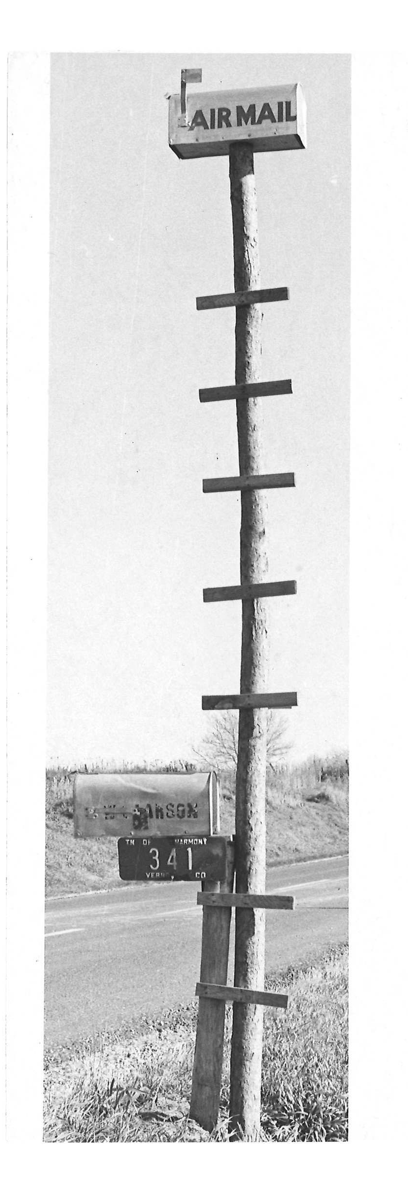
Mailbox, made by Doris Bishop's husband, on Clifford Heavrin's farm, West on 56. 1970s.
Around 1918 most of our mail was carried across the country by train. The trip across the country took 100 hours. Trying to speed up delivery, US Army pilots started flying the mail until the Post Office began to hire its own pilots and buying its own planes. Since there was no form of radio communication, pilots had to fly by sight or use something called dead reckoning. They could only fly during the day and in good weather. At night the mail would be transferred to a train until the next morning, when another plane took over. That process was costly and did not speed up delivery.
Flying was a very dangerous job. Pilot Dean Smith, a survivor of mail flight, called it a “Suicide Club”. Of the more than 200 pilots, 35 died in crashes, 20 of them before 1920.
By September 8, 1920, a transcontinental air route was being developed similar to the rail system and early highways. Assistant Postmaster General Otto Praeger knew that delivery could be sped up and more profitable if the planes could fly day and night. To prove this, he set up four day and night flights between New York and San Francisco with two planes going west and two going east. The airport runways would be lit with bonfires at night. Pilot Jack Knight, flying with a broken nose he received in an earlier crash, was able to fly from North Platte Nebraska to Chicago in a snowstorm by finding Lake Michigan and then on to Chicago. Even though one pilot crashed and died and two other pilots were grounded in a snowstorm, the experiment was considered a success. Seven pilots flew the mail 2,629 miles east bound in 33 hours and 20 minutes.
Beacon towers soon replaced the runway bonfires. The first beacon system was set up by the Army, not the Post Office, and by 1922 it ran from Dayton, Ohio to Columbus, Ohio. In 1923, Congress provided funding for a nationwide network of electric light beacons. The entire route was lighted by the summer of 1925. Eventually this system was organized into 34 numbered routes called Contact Airmail (CAM) routes. By 1932 there were more than 46 routes. These routes were referred to by their terminus cities. For example: Chicago-St. Paul.
The towers were placed 10 miles apart on private property. They were a standard of 51 feet high topped with a Fresnel rotating light (that’s the same kind of light used in light houses) that was visible for 40 miles. Below that were two course lights pointed forward and back using a single Morse code letter to identify the beacon’s number. The Morse code would flash every ten seconds. The pilots used a mnemonic to help them with the code:
(WUVHRKDBGM) When Undertaking Very Hard Routes Keep Directions By Good Methods. At first the beacons stood in the center of a 70-foot-long concrete arrow painted chrome yellow, with a generator shed at the feather end. Later the concrete was replaced with sheet metal. The route number was painted on the roof of the shed. The land was leased from the private owners for periods of 5-10 years at an average rate of $4.87 per acre per year.
By 1933 over 1,550 beacons were in place, lighting over 18,000 miles of airway. Even after air to ground communication was being used, the FAA did not decommission the last beacon located in Whitewater, California until July 20, 1972. That beacon is now in the National Airport Space Museum in Washington DC. The state of Montana continues to maintain 16 beacons as guides through the mountains.
Western parts of the United States are still dotted with the remains of the 70-foot concrete arrows, but in this area only a small number remain. The closest remaining artifacts of the beacons are in Minnesota. There is a concrete arrow in a farm field in Cottage Grove and a refurbished lighted tower in Indian Mounds Park in St. Paul.
Looking through the 1932 Vernon County Censor we see that 5 beacons were installed around this area in 1932. One was in Lone Rock, one in the Town of Sylvan, and another near Brinkman Ridge in La Crosse County by Bartsch Road.
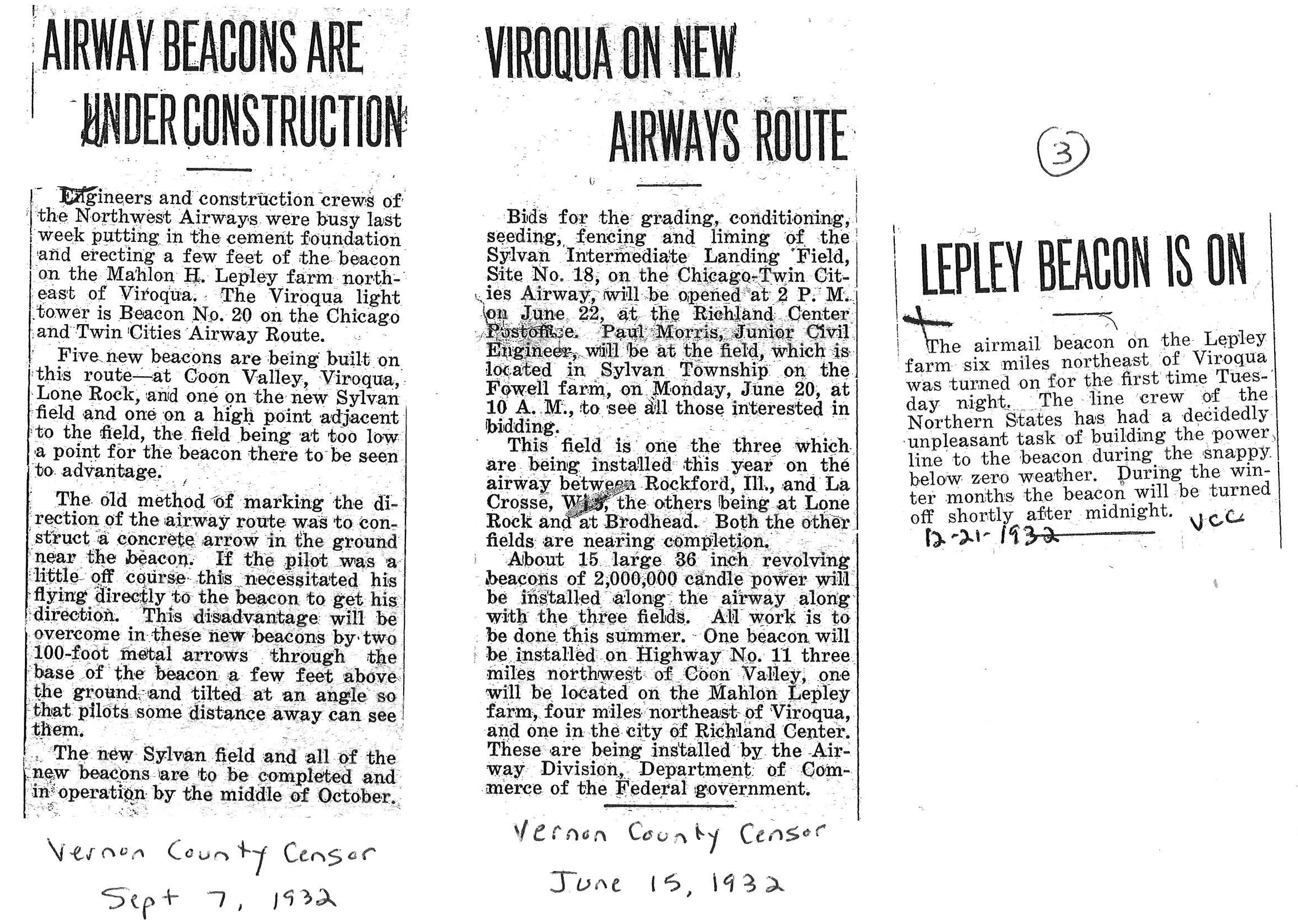
Vernon County was also home to Beacon No. 20 on the Chicago and Twin Cities Airway Route on the Mahlum Lepley farm on North Asbury Road, near the landfill. This beacon and the concrete arrow are gone now but there are some folks in the area who remember them.
During WWII most of the towers were torn down and the metal recycled for the war effort. The concrete arrows were either covered up or destroyed because officials feared that enemy aircraft could use them for navigation.
While the beacons have faded from our history they have been credited with developing the modern mail system we all appreciate today.
Many thanks to the following people who provided stories and information about the beacons:
- John Michael Jaeger from the Kelch Aviation Museum in Broadhead, WI, who ignited the search.
- Wayne Kruizenga, for giving me information about the possible location of the tower.
- Sandy Iverson, who shared several memories her late husband Ronnie had about the beacon. When Ronnie’s brother was a child he climbed the tower and had to be talked down.
- Dan Jacobson, who remembers pieces of the concrete arrow getting turned up in their tobacco field.
- John and Lars Langaard, who knew the location of the Bartsch Road beacon.
- Special thanks to Monique and Laurence at the Vernon County Land Office. Your patience, determination and willingness to drop whatever you were doing to help me find the Vernon and La Crosse County beacons was so appreciated.
Sources:
“How We Found Our Way” by Tom Charpentier, Oct. 17, 2019.
“An Airmail First” by Michael L Wilson. WI Magazine of History. Fall 2025 issue.
Vernon County Censor, 1932.
“Nocturnal Travels” by John Schamel.
“Remember the Air Mail Pioneers” by Nancy Allison Wright.
Mavericks of the Sky by Barry Rosenberg and Catherine Macaulay. 2007.
Jack Knight’s Brave Flight by Jill Esbaum. 2022.
“American Aviation Heritage,” National Park Service.
“Arrows Across America,” dreamsmithphotos.com.